Be part of the future with us!
Register now for our online product launch event on May 23rd.
Although often unnoticed, we count on satellites every day for weather forecasts, mapping apps, international communications, and many more services. These services were once the exclusive domain of large, multi-tonne satellites. The role of small satellites, however, is growing quickly as the new space economy is booming.
Telstar 1 reached orbit in 1962 and proved that commercial satellites could relay telephone, television, and other communications across oceans. The 78 kg Telstar would be considered a small satellite today, but its successors quickly grew larger, more massive, and more capable. A geostationary communications satellite uses its high orbits to provide voice, video, and data services to entire continents.
A small satellite in LEO usually covers a smaller region. However, that low orbit does provide several advantages:
Rather than rely on a single satellite, new space applications use tens, hundreds, or thousands of satellites to cover the entire planet. These small satellite constellations can provide voice and Internet service and enable novel Industrial Internet of Things applications.

For example, NanoAvionics has launched multiple small satellites for OQ Technology, the first 5G IoT operator, building a global hybrid system that combines both satellite and terrestrial wireless networks. It’ll enable the expansion of the 4G and 5G IoT footprint globally, which plays a critical role in enabling mobility in vertical markets such as smart cars and drones, transport, logistics, and maritime. Moreover, it provides a unique value for low latency applications (which are critical for 5G) as the satellites are in low Earth orbit and provide few milliseconds latency communication, which traditional GEO satellite operators cannot do.

The United States began deploying its Global Positioning System (GPS) in the 1980s. For the first time, navigators could determine their precise locations simply by triangulating the position of GPS satellites in the sky. Other positioning systems, such as Europe’s Galileo, followed later. Commercial applications are so ubiquitous that many people never realize their apps depend on satellites.
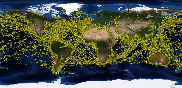
Although these major networks rely on large satellites that can weigh many tonnes, small satellites also provide navigation services. Tracking ships and aircraft that travel far from shore was once extremely difficult. Today, small satellite constellations detect the identification signals these vehicles transmit. With precise location information, transportation companies become more efficient, authorities can detect suspicious activities, and rescuers can save lives.
Read more on how satellite navigation works.
Low Earth orbit provides a unique vantage point for observing our planet. Reconnaissance and intelligence were the first uses of pictures from space, but Earth Observation (EO) soon found many scientific and commercial applications:
Here, too, small satellites are taking on roles once limited to large, multi-tonne vehicles. Small satellites can take higher-resolution images from their lower orbits. In addition, EO services based on constellations can image the same region more frequently or provide real-time video. These new EO small satellites give urban planners, businesses, and environmental regulators capabilities they never had before.
For instance, a 16U satellite built for SEN provides real-time Ultra-High Definition (UHD) videos of Earth. It helps society witness the evolution of life on Earth (and eventually – beyond) and monitor the planet’s health.
A 6U small satellite (the size of a shoebox) is also currently being built for the world’s first global biodiversity observation mission. The satellite is designed to observe all 51 billion hectares of Earth’s surface biodiversity. It will collect hyperspectral imaging data, which will help identify, measure, and track the value that each ecosystem generates daily.

Although scientific research and technological development has defined the Space Age from its beginnings, small satellites are opening new avenues for progress in space. Standardized designs, low-cost components, and affordable access to orbit make it easier than ever to develop a science mission or test new technologies in space.
Astronomers use small satellites as space telescopes. Startups demonstrate new propulsion systems or solar sail innovations. Even space agencies have used small satellite technologies for missions to the Moon and Mars.
In January 2023, Europe‘s first solar sail mission was launched aboard SpaceX Transporter-6. Missions for small satellites with solar sail technology could include getting data about Neptune’s atmosphere or Uranus’ magnetosphere, performing low-cost asteroid reconnaissance missions, carrying cargo to the Moon or Mars, sending rovers to Titan or Venus, and helping to remove space debris.
Learn more about how solar sails are remaking space exploration: